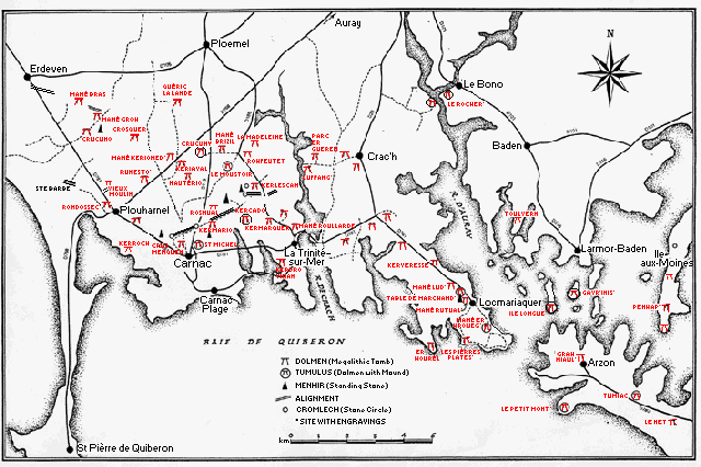
Dolmen / Passage and Gallery Graves
The dolmen are megalithic tombs built of stone. Most were probably covered by a mound of earth and/or stone. The older ones were family or community graves, used over many generations. The oldest dolmen in the Carnac area was built 1000 years before the pyramids in Egypt.
There are two main types of dolmen: passage graves which were covered by circular mounds and gallery graves which were covered by long mounds (called round barrows and long barrows in Britain). Most of the dolmen in the Carnac region are passage graves. Other large groups of passage graves are found in southern and western Spain, southern England and in central Ireland. Gallery graves are more widely distributed throughout France and the rest of Europe, especially in northern Germany, Scandinavia and Britain. There are some particularly large gallery tombs in the Loire Valley in France.
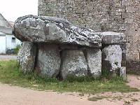
The simplest and oldest form of passage graves is a round or rectangular chamber connected to the entrance by a corridor. The passage was lined with upright stones covered by horizontal lintels. The chamber, also lined by large stones, was roofed either by huge, flat stones called capstones or by a corbelled dome. Some of the capstones weigh 40 - 50 tons.
Later three variations of the simple passage dolmen evolved. The wedge-shaped dolmen had no distinct separation between the passage and chamber; the passage was simply wider at the inner end than at the entrance. The second type is a very long wedge-shaped tomb with a bend of up to 90° about half way along the passage. In the transeptual passage dolmen, one or more side chambers open off the passage near the inner end. This last type is not very common around Carnac but is the major type in Ireland and the Orkney Islands north of Scotland.
The gallery tomb is a long rectangle, often divided into compartments by slabs of rock, and covered by a long mound of earth and stone. They are either roofed with large capstones or the walls are inclined to rest against each other forming a triangular chamber.
The map below shows the locations of major dolmen in the region around Carnac and the Gulf of Morbihan. There are more dolmen than are shown here; some are badly destroyed, others inaccessible in woods or farmer's fields and still others not marked on maps and only found by pure luck. We could not find all the dolmen marked on our maps. Hopefully more will be located and photographed in future trips to Carnac.
Simple Passage Dolmen (Arranged from west to east)
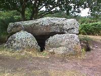
Crucuno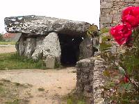
 |
About half way between Plouharnel and Erdevan in
Crucuno village 1864 description says chamber plus passage was 27 metres Only chamber remains today; until lately was used as henhouse and storage shed |
Rondossec
 |
Plouharnel Southern dolmen of group of three is a simple passage tomb Central wedge-shaped dolmen has a 6-metre chamber with engravings The northern dolmen has an 11-metre long passage and a small side-chamber Gold necklace, vases and stone axes were buried in the dolmen |
Kergavat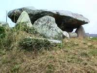
|
About 1 km SE of Plouharnel,
on the road to Carnac |
Kerroch  |
In the town of Kerroch, 1 km
SSE of Plouharnel |
Cosquer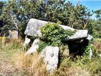 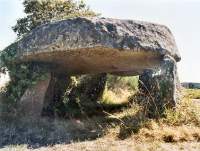
|
About 3.5 km N of Plouharnel,
at village of Cosquer |
Runesto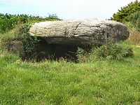
|
About 2.5 km NE of Plouharnel,
at village of Runesto |
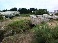
Quéric la Lande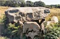 East dolmen 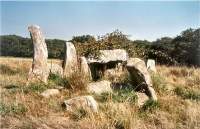 West dolmen |
About 5 km north of Le Ménec
village, about 1 km east of Le Hahon village The stone circle at the west end of the Le Ménec alignments, the Mané Kerioned dolmens and the Quéric la Lande dolmens lie on a north-south line In the upper photo, the west dolmen is just visible at the right tip of the capstone The west dolmen, often used to hold hay for the cattle, is in a very bad state |
Nautério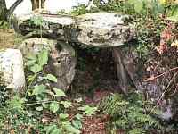
|
Just north of village of Nautério,
about 1 km SW of Mané Kerioned and Keriaval dolmens Badly overgrown There is supposed to be another dolmen and menhir in a woods 1 km SE of Nauério - we couldn't find it |
Carnac - Cruz Menquen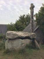
|
Northern outskirts of Carnac, about
500 metres SE of Le Ménec alignments A cement cross has been stuck on the capstone The passage has disappeared |
Mané Brizil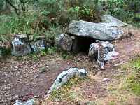
|
About 1 km NW of Le Moustoir tumulus In woods beside private house Chamber capstone is missing |
Rosnual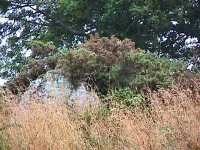
|
About 1 km north of the Kermario
dolmen Has deteriorated badly in the last 20 years |
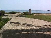
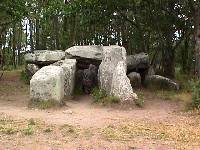
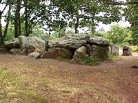
Kermario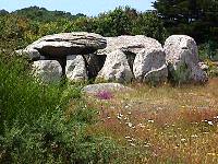 |
Southwest end of Kermario alignments (photo on homepage) Older than alignments Amber beads and stone axes found buried in dolmen |
| Kerluir | About 1 km south of Kermario dolmen On small hill covered with thorns and brambles (we didn't find it) St. Michel tumulus, Kerluir dolmen and Kercado tumulus on a line parallel to Kermario alignments Fine menhir to west |
Le Moustoir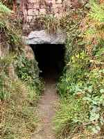
|
Tumulus, 2 km north of Kermario alignments,
contains two dolmen One is a simple passage dolmen with an engraved axe The other seems to have side chambers but the passage may have been built recently (also listed as 2 burial chambers) Has menhir on top and one at west end |
Kercado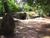 |
South of west end of Kerlescan alignments,
northeast of Carnac Engraved stones in dolmen Covered by 25m-diameter tumulus, supported by kerb stones, surrounded by 35m-diameter stone circle, topped by menhir |
Rohfeutet or Roc'h Feutet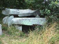 |
At edge of woods half a km west of La Madelaine chapel |
La Madelaine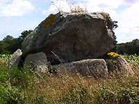 |
Near La Madelaine chapel, northeast of Carnac Passage has been destroyed, capstone dislodged |
Kervilor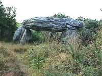
|
SSE of Le Petit Ménec alignments
and Kervilor village Passage is missing |
Kerdro Vihan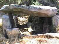
|
In La Trinité-sur-Mer, up the hill SW of the sport grounds |
Parc Er Gueren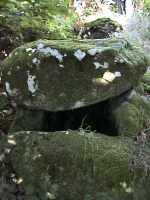
|
About 500 metres NE of Luffang, near
Crac'h Circular chamber is missing its capstone A second dolmen about 20 metres to the north has a huge circular chamber, no capstone, very overgrown |
| Kercadoret | Northeast of Kerveresse and Locmariaquer One of oldest dolmen in Locmariaquer |
| Kerveresse | Northwest of Locmariaquer One of oldest dolmen in the region Engravings |
Kerlud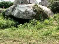
|
West of Locmariaquer Only chamber with massive capstone remains |
Mané Lud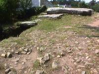 |
Locmariaquer, 200 metres north of the
Marchand's Table Fine engravings - boats, face? Mané Lud, Kercadoret, Mané Rutual and Kerveresse are the oldest dolmen in Locmariaquer |
| La Table de Marchand
(Marchand's Table) 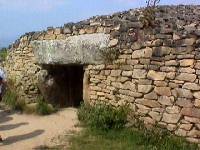 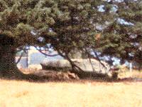
|
In Locmariaquer beside Le Grand
Menhir Brisé menhir and Er Grah tumulus Chamber capstone, a piece of the same stone as Gavr'Inis capstone, is engraved with an axe and an animal (antelope?) Rear upright stone of chamber is beautifully engraved with hook-shaped forms (grain?) Pottery was found on either side of the entrance Circular mound supported by 2 rings of granite blocks (reconstructed in the late 1980s) Archaeologists discovered the floor hearths and postholes of an earlier building under the mound and the holes of an alignment of 16 upright stones on the northwest side The lower photo was taken in 1983, before restoration of the site |
Mané Rutual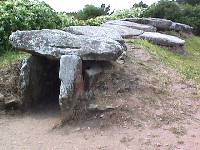
|
Locmariaquer, 300 metres southeast of
the Marchand's Table Enormous capstone weighs 50 tonnes It and Mané Lud are probably the oldest dolmen in Locmariaquer Engravings |
Gavr'Inis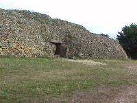
|
On island in Gulf of Morbihan, reached by boat from
Larmor-Baden Chamber is 3.5 meters square, passage is about 15 m long Capstone weighs 40 tons and is a piece of the same rock used to roof the Marchand's Table and Er Grah dolmen at Locmariaquer 23 of the 29 supporting stones and the capstone are engraved; the symbols used are found at neolithic (New Stone Age) sites from Scotland and Scandinavia to the Canary Islands. The tumulus covering the dolmen is a stepped pyramid 55 meters in diameter (see Tumuli page) This is one of the most beautifully engraved dolmen in Europe |
Le Petit Mont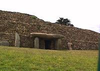 |
Southwest end of Rhys peninsula Tumulus contained at least 3 passage graves The southwest dolmen is engraved with axes, circles and serpentine lines. Unfortunately not open when we were there, so photo taken through fence One of the dolmen was destroyed in 1943 when the Germans build a bunker in it |
Grah Niaul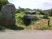 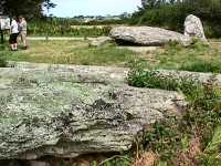
|
Western end of Rhys peninsula, 500 metres
WNW of Arzon Menhir at entrance Contains engraved stones |
| Île Longue | Dolmen at southern end of Île Longue,
island west of Gavr'Inis in Gulf of Morbihan Engraved stones |
| Île aux Moines and Penhap | Île aux Moines, largest island
in Gulf of Morbihan, has at least 3 dolmen, a menhir, and a stone
circle Penhap dolmen, NW of Penhap village, is largest and best preserved dolmen on the island and has engraved stones |
Wedge Dolmen
Rondessec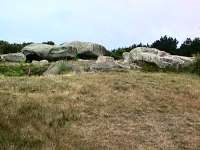
|
In Plouharnel, a mound with 3 dolmen The central dolmen is wedge-shaped |
Mané Kerioned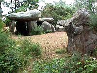
|
4 km NE of Plouharnel 3 dolmen, all wedge-shaped Western dolmen (upper photo) is 9 metres long Centre dolmen is at right angles to the other 2, forming a U-shape The eastern, underground dolmen has several engraved stones Remains of cromlech or outer wall of tumulus - stone in foreground of upper photo - surrounding the 3 dolmen |
Angled-wedge Dolmen
Luffang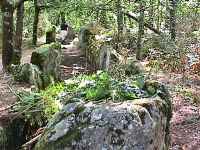 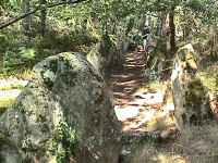
|
West of town of Crac'h on east bank of
Rivière de Crac'h All the capstones are missing Often listed as a covered alley but closed end is definitely wider than open end (upper photo) Has definite bend in passage like Pièrres Plates (lower photo was taken at bend) Engravings - some of engraved stones are in the museum in Carnac |
Les Pièrres Plates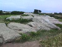
 |
On coast 1 km south of Locmariaquer Wedge-shaped with 120° angle Additional chamber at bend Several of the supporting stones are beautifully engraved "Menhir" at entrance (lower photo) was a lintel |
Le Rocher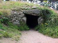 |
Tumulus southwest of Le Bono on east bank of Rivière
d'Auray Engravings |
Toulvern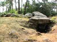
|
About 2 km south of Baden Two dolmen in the remains of a tumulus One dolmen has all its capstones; it has a definite bend in the passage |
Transept Dolmen
Mané Braz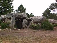
 |
2 km southeast of Erdeven and 1.5 km
east of Kerzerho alignments. Slightly more than 1 km northwest of
Mané Groh 4 side chambers At least 2 other smaller dolmen in group Dolmen are built in and on a hill which looks like the remains of a tumulus |
Mané Croc'h or Mané
Groh |
2 km south east of Kerzerho alignments, about 1 km
north of Crucuno village 6-m long passage with 4 transeptual chambers near inner end Pottery found in dolmen dates to 2000 BC Coffin grave behind dolmen |
Rondossec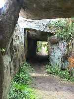
|
Northern dolmen has a rectangular chamber
with a small side chamber on the south side The passage is 11 metres long |
Keriaval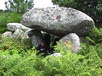 |
Northeast of Plouharnel, near Keriaval alignment
and across the road from Mané Kerioned 4 transeptual chambers |
Kermarquer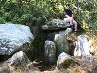
|
About 1 km SSE of Kerlescan village beside
the road to La Trinité-sur-Mer, on top of a small hill Main chamber plus a side chamber |
Gallery Graves
| Le Manio | The grave associated with Le Manio menhir near the
eastern end of the Kermario alignments Older than the alignments |
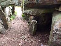
Kerlescan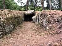 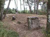
|
North of the Kerlescan alignments Entrance is on the right (upper photo) in the side of the passage The long, narrow mound is surrounded by a rectangle of stones (lower photo) |
Mané Roullarde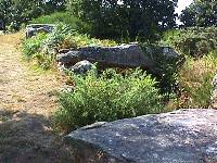 |
Northern outskirts of La Trinité-sur-Mer |
| Bilgroix | Rhuys Peninsula, 2 km northwest of Arzon on Point Bilgroix |
| Le Net | Rhuys Peninsula, 2 km southeast of Tumiac tumulus near village of Le Net |
All photographs were taken by myself, during trips to the megaliths of Carnac in 1980, 1983, 1994, 1998, and 2002. All photographs are my property and may not be copied or used without my written permission.
Table of Contents
Types of Megaliths
of Carnac
September 1, 2003
©copyright 1999, 2003 Vicki Sherwood
E-mail: vsherwood@simon-kucher.com
This page is hypertext https://menhirs.tripod.com/dolmen.html/